Check out our other blogs as we aren’t posting here anymore.
People and Places Blog: http://www.tjandmark.com
Our ranch blog: thechapmanranch.com
Our hiking blog: happiesthiking.com
Thanks for stopping by.

30 Friday May 2014
Posted in Uncategorized
Check out our other blogs as we aren’t posting here anymore.
People and Places Blog: http://www.tjandmark.com
Our ranch blog: thechapmanranch.com
Our hiking blog: happiesthiking.com
Thanks for stopping by.
17 Sunday Nov 2013
Posted in Hiking
We decided to go back into the Sierra during the time between when my mother died and when her services were to be held. It just felt right and it soothed my spirits especially.
We decided to go back into an area we hiked many moons ago as young married couple. It was one of our first backpacking trips together and then it felt like quite a big hike. This time it felt way too short.
 We didn’t get to Clover Meadow Ranger Station until about 3 in the afternoon, by the time we hit the trail it was close to 4. It felt like being embraced by a long-lost friend; so warm, comforting, and safe.

The hike began in the trees and cattle milled about here and there. Lovely. Our first night’s camp at Vandeburg Lake was about 6 miles from Clover Meadows. I hiked at high-speed, which isn’t too fast as my legs are quite short and at times the trail steep. Sweat rolled down my back like water on a cold glass. Mark struggled a bit and had to take a few trips out into the woods. I thought I was invincible and he thought he might be getting a stomach bug.

We got to the lake a little before sunset and Mark discovered his flu was a huge, heavy rock in his pack. He had been carrying an excess of 10 or 15 pounds that our oldest son, Zac, had hidden in his pack. Old family trick that Mark had played on Zac when he was a teen and had hiked too fast for us. Payback. We had a good laugh and left the autographed rock beside the lake for us to visit in another 20 years or so.
 We watched the glow from the sunset and I felt relief for my mom’s release from her crippled mind, but also guilt that I didn’t spend more time with her. Isn’t that almost always the case? Sadness gripped me too. Both my parents are now gone. I wanted to cry, but couldn’t.
Nature hugged me and I hugged back.
 The morning came quickly and we tore down camp excitedly to get hiking. The sun was warm and the air had a small taste of fall’s crispness. We spent a lot of time hiking on the granite and with sweeping views to the south. We could see the seven gables that we passed last year on the JMT.
We also came across a group of rangers doing trail and camp work and were pleasantly surprised to know one. When Mark was a volunteer ski patrol member, this man was the boss. We had a great visit. You just never know who you might bump into in the woods. Back in the day, Mark and I had a lovely chat with Captain and Tennile on the route to Half Dome.

Lillian Lake is lovely and we stopped for a morning snack.
 Onward and upward to Rutherford Lake. I think there was about 6 or 7 miles between Vandeburg and Rutherford. I really don’t pay much attention to the miles passed, I just enjoy the view and the feel of the dirt beneath my feet.

Rutherford Lake is a beautiful alpine lake, but it wasn’t our stop for the day. While there was a trail to our destination, we wanted to follow an old route of ours as many, many years ago we had been here and then had proceeded down the slope to Anne Lake nestled amidst the trees. We knew just the spot to go for an afternoon dip off of a big, flat, granite rock.

Isn’t she lovely. We had a great afternoon here all by ourselves. We felt a bit like Adam and Eve.
 Reflected clouds on Anne.
 Morning glow of the next day.

Clouds rolled overhead but our hike was dry and beautiful and mostly down hill for the 12 miles back to our car.  Good bye old friend. See you next summer.
28 Monday Oct 2013
Posted in Uncategorized
I wish we were on the trail, this late October day, and memorializing this last section of our summer PCT hike is bittersweet. Bitter because I want to be there NOW and sweet because the memories are fondly held.

The gang of four, got a ride from our Kennedy Meadow’s neighbor, Steve, to the top of Sonora Pass so we could pick up the PCT again. This saved us about 9 miles and a four thousand foot climb. It was a welcome lift and we were all really happy to be back on the trail.

You could see the expectation of a really good time ahead on our faces and in our body language.  I led out and felt the pressure of being the weakest hiker and took off too fast and was soon gasping for breath from the climb and the elevation.
 Big sweeping views were our trail-side friends. From the pass it was- thankfully- down, down, down.
 Into a world that has lava formations and some granite.
 Fields of flowers,
 gave our avid photographer a reason to crawl around.
 These shrubs look like they are turning yellow for autumn, but on closer inspection we discovered they were covered in some small organism.
 It was another day of turquoise skys, billowy clouds, red rocks, wildfowers and babbling brooks. 10 miles had us camped on the east fork of the Carson River amidst the forest and under a ghoulish carving in a tree that I didn’t photograph. It creeped me out! Mapster had this location chosen from the information he had acquired online, but we overshot it and Mark acquired his nickname of ‘Apster’ when he pulled out his iphone and opened his Halfmile’s PCT AP and pinpointed our location. (Great AP, highly recommend it to those hiking along the PCT).
 Day 2 dawned clear, but soon clouds blew in and thunder chased us along the trail.
 We entered cattle country and were serenaded by their bells. This was the first time we saw cattle along the trail and it brought sweet smells of home.
 I love cows! I think this one was embarrassed by her bell. I know our cattle at home would have been. 😉
 It threatened rain all day and spit on us off and on. I kept putting on my rain gear and then taking it off again. We’ve gotten caught in downpours before and it is hard for me to recover warmth after a drenching, so I try to be safe.
This day was lazy and meandering and fairly easy. Some of the trail wound through forests, other along brush covered ridges and by rock jumbled points, lava as well as granite. We saw two huge mounds that were very similar to Devil’s Postpile.
 End of day 2 had us at Wolf Creek were we sat around our stoves and talking. Conversation fell to marriage. We shared that the secret of our 32 years was, ‘lowered expectations’. We always get a laugh out of that, but acceptance is key to a happy marriage; we know that sometimes we will each fail to do our best, and that’s OK. We have high expectations for ourselves, but don’t expect too much from each other. We do what we do for each other out of love, and not out of a need to get something in return. At least on a good day.
 Day 3 started out beautiful and we had high hopes of doing some swimming. We got to this little lake too early in the morning and decided to wait for the next lake.
 The terrain opened up, became more bare and we could see smoke in the distance. A lot of smoke.
 The sky turned dark. Our afternoon swim vanished in a pool of smoke. The bitter taste burned my throat. I put on a mask to protect my asthmatic lungs. It was very eerie.
 I invented elaborate stories in my head to entertain myself. We were fleeing a volcano. It was after the Apocalypse and we were the last humans on earth.
 As ash fell like snow, disappointment wove itself into all our hearts. We began to get a sinking realization that this was a big fire event and probably the end of our hike.
 And it was. While our plan was to hike to Lake Tahoe, Ebbett’s Pass was the end of our trail. Naked Dave’s sister picked us up (thank You!) and we learned that the Rim Fire was huge and the smoke not expected to blow the other way. Another case where an ability to lower your expectations comes in handy.
It is strange too how these things can turn out for good, if you have eyes to see. My mom, who had Alzheimers, had fallen and had a cerebral bleed. Because we exited at this time, Mark and I got to be with her for the last four days of her life. She held my hand, she smiled. We could tell she was comforted with us there. It was good, just as our hike was too. Even the smoke. I will never forget that smoke!
19 Saturday Oct 2013
 My last post had us arriving at Kennedy Meadows Resort. (Not to be confused with the Kennedy Meadows Resort in the south.) Kennedy Meadows has a pack station, store, restaurant and saloon as well as a tent camping, RV camping and many cabins to rent. They also have laundry facilities. Yay! Most of the cabins are new and the first night we stayed in one of these. The prices are very reasonable and I thought it would be a great place for a family to have a get together.
The gang was now just the four elders as both Legs and Flash had to return to their everyday lives. We enjoyed the place and tried to find things to do. It was kind of weird not walking. We ate and drank a lot. Prime Rib the first night. Yummy. We had a rollicking tournament of horseshoes that got down to Naked Dave and Mark. It was a close game, but Naked Dave won. The finalists were hilariously entertaining. They would wag their bottoms and jump in the air and bump bellies shouting “bully”. Laughter was infectious and filled the air.
We ran into the Australian hikers, Trevor and Jackie, and had time to sit and chat more. Jackie was an outdoor educator at the university level and Trevor a retired General Practitioner who had also written an adventure travel book about kayaking in Russia. Mark and I have since read the book and loved it. It’s on Amazon and called, Paddling Through an Enigma: Whitewater Rafting and Mountain Journeys in Siberia and Middle Asia.
 This is Rose Cabin. The oldest cabin on the place built-in the late 1800’s. It was like entering into a time portal. Loved it. They don’t regularly rent it out, but the gang of four got to share it for the second night. (Although Mark and I slept outside because as well as being seeped in history it’s seeped in smoke).

07 Monday Oct 2013
 After a hearty breakfast at the Tuolumne Meadows grill, we headed south on the Pacific Crest Trail. I led out, and my heart was bursting with expectation. It’s always like that for me in the morning on the trail and especially the first day of an excursion into new territory with people I hardly know. I was so excited I felt like my feet were barely touching the gorgeous granite slabs that we hiked on.
 “Legs”, the geologist, gave us an impromptu lecture on the forces that create such beauty. She is passionate about geology and hearing her talk made the rocks go from hard inanimate objects to something almost alive. When I look at rocks now I often see time and energy flash before my eyes like a moving picture show and I think of the easy friendship she and I developed on the hike.
 It was a fairly easy, beautiful and short 6 miles to Glen Aulin High Sierra Camp. The waterfall and pool are gorgeous and great for an afternoon swim.
 The water embraced us vigorously with icy cold hands. I think we all gave a little gasp of surprise. Naked Dave (who wasn’t naked) was the first to venture behind and through the water falls. His head went under for a bit, but it all worked out and soon others in the group followed his example. We fished here too and I caught a nice rainbow trout on a gold spinner. The camp itself was my idea of what east coast summer camps might have been like, with its many well-heeled tourists.
 Early the next morning we were anxious to leave Glen Aulin and the crowds behind. (While the crowds did thin, there was a pretty steady stream of hikers going north.) We had about 8 miles to hike before coming to the next reliable water. The group split up. Which ended up being our pattern for most of the hike. It was just easier for everyone to hike at their own pace and meet midday and at camp.
 The hike itself began very flat with a long walk up cold canyon. At the top of the canyon we came to a lovely forest of red pines. We also officially met Trevor and Jackie from Australia. We had seen them the day before, but only in passing. This day we exchanged names and I wondered about their occupations. Jackie and Trevor roughly had the same hiking plan as ours, so they unofficially became part of our gang too. Lovely, interesting couple who stopped with us midday for a quick dip in a creek and a bite to eat. The hike after lunch became more difficult as we had to do a bit of climbing and it was hot. Mark opted to stay behind and hike with Naked Dave and Flash so for the first time in my life I backpacked alone. It was strange but nice and I kept trying to walk faster to catch the Mapster and Legs. But I never did.
 Miller Lake was our camping destination and it was my favorite part of the day. I took a sublime solitary swim in its cool, not cold, water. With granite rocks on the east, sandy shore on the west I breast stroked down the lake through blue above and blue below. A wonderful ending to about 12 miles of hiking.
 In the morning Legs and I headed up the trail first and this doe came right at us like she had a message to give us. It was a bit strange, but sweet. I thought we had perhaps landed in Narnia.
 Little did we know what this special day would bring and how we would find ourselves in a Survivor episode or perhaps a fairy tale by the brothers Grimm. Perhaps that doe did have a message for me and I just didn’t listen.
 It seemed as if we had landed in the southwest while climbing the 1600 feet up to Benson Pass. The trees were spaced well apart and there were many rocky outcroppings. I had to jog to keep up with Legs so I waited to hike with Mark and we had fun tracking Legs with her trademark Keens.
 We caught up to her at beautiful Smedburg lake were she was slaying fish. Blood lay gobbed on the granite rock where she had bludgeoned the head off her first catch. She apparently couldn’t find a knife. She ended up catching a total of 3 big fish and after the whole gang came together we fried them up and ate them.
  Most of us swam too. You can see me way out there if you look hard. Coming out of the lake I sliced my arch on a sharp piece of granite. Luckily the Mapster/doctor was in and had it steri-stripped in no time. It was late afternoon, and Flash was struggling with adjusting to altitude, but we decided that we needed to get further along the trail to be able to make Kennedy Meadows by Sunday. The Mapster and Legs left the lake first. Remember this.
 Naked Dave, Flash, Mark and I began the hike together but I soon scooted ahead to try to catch up to the others. The trail began with a short section of up, but then it began a quick descent. I came to the area we had decided we were going to camp at, but Legs and Mapster weren’t there. I checked for Legs footprints and found them continuing on, so I did too.
 Things were beginning to feel weird and the shadows grew long. I wondered where everyone was. Then I heard a commotion behind me and found Mark running down the steep trail to tell me that Legs and Mapster had accidentally gone off trail at the lake (AKA: Got Lost!) and I was the one everyone was trying to catch… OOPS! Apparently, someone else is also wearing size 9.5 woman’s Keens.
 By this time we were well past that intended camp site and no water was available until Benson Lake , a few miles away. It got dark and we hiked on and on through what now seemed like sinister woods with boogey men or the Big Bad Wolf lurking around every corner. Legs had some whiskey along and shared. Our fortitude strengthened we made it to the lake. The beach glowed white in the moonlight and I fell backwards over a log laughing and donkey’s brayed and bells tinkled. It was surreal and fun and an epic day of hiking 15 or 16 miles.
 The next morning came soon and we were treated to a beautiful view. Benson lake is aptly called the Riviera of the Sierra for its white sand beach. It was really pretty, but crowded. It is popular with the horse packers and groups.
  Today’s hiking felt uneventful after yesterday’s adventure. I made sure to not scoot ahead. We traveled up through fairly open terrain.
 After a midday break at another sparkling lake we continued over a small pass.
 There were flowers and currants and fresh spring water flowing from rocks above the trail. (To prove they were currants Naked Dave ate handfuls)
 The canyons here are steep and the movie Jeremiah Johnson came to mind and I thought how I wouldn’t want to get caught here for the winter. This area of the Sierra is called the wash board for a reason. We passed Jackie and Trevor’s tent along an almost dry creek, but didn’t see them. First day of hiking we didn’t get to chat with them.
 The last bit of the day was hot and steeply up and then steeply down. I think the down felt tougher. We camped as soon as we made it to stubble-field canyon creek. A trail work camp was near us and we heard them singing Happy Birthday to Andre’. I wondered if they had cake, but was too shy and tired to go ask. I think we hiked about 11 or 12 miles this day. I didn’t keep good records of the mileage. White Lightening, a PCT hiker, who was way behind schedule, camped with us and we shared some food. The darkness came quickly in the canyon and we ate quickly and went to bed. There was a lot of noise in the night and I dreamed of wild animals and robbers. Of which there were none. It was only Legs relocating due to the snorers and the neo-air mattresses which sound like someone is wrestling midgets.
 We met Andre’ the next morning and wished him a happy birthday. This photo is not him. This is Ryan from Cal Poly. He was the trail boss and enjoyed his time fixing the trails. We enjoyed their work too and made sure to thank them.
 Midday had us at lovely Wilmar Lake first so I decided to go skinny dipping only to end up having other hikers go by. OOPS. My mistake. By the time the coast was clear I was a frozen Popsicle. Mark and I washed clothes with our bag method and hung them up to dry. The group arrived and we discovered that Flash had sprained his ankle. Poor guy. Legs, renamed The Trout Slayer, caught some nice ones while Mark and I got skunked.
 Gorgeous sky overhead and with a fairly flat trail ahead the afternoon hike to camp was near perfect for us.
 Grace Meadow, our camping destination, had a small creek full of little fish that I taught to fly. We met up with the Mapster who had been in the lead and picked a camping spot. He had hiked a lot further looking around for the perfect sight and we appreciated his scouting. Later the others joined us and we all camped apart like a little village.
 I awoke feeling sickly, but enjoying the beautiful sky made me forget about it. Leg’s Achilles heel was bothering her so she hiked with us mere mortals.
 We horsed around and did photo shoots at Benson Pass. We could tell we had exited the ‘wash boards’ as the countryside was wide open. Frankly, it was a relief as the hiking up and down the canyons had been difficult.
 It was an incredibly gorgeous day and we took the time to sit and enjoy the flowers, sky and sunshine.
 Flash looking as dapper as ever.
 So pretty and western postcard appropriate. I thought about the emigrants who brought their wagons and all their belongings right through here. And while these photos make the land look fairly flat there was quite a few steep ups and downs.
 Legs and her dad got a chance to hike together.
 Leech Lake. Well, really it’s officially called Emmigrant Meadow Lake, but after swimming, the Mapster calmly pointed out leeches on Leg’s legs. Needless to say, we all checked our bodies thoroughly.
 Brown bear Pass. This photo does not do justice to the flowers everywhere.
 A rock perched prettily.
 Our camp for the last night on this section. We had purchased a new tent this year. A Big Agnes Copper Spur 2. We loved it for its 2 doors, ease in setting up, lightness and room for the two of us and our gear. As you can see, it even has an easy way to attach and anchor the rain fly, just in case, but sleep with the stars! It’s a keeper.
 Morning came quickly and we enjoyed waking up to our favorite mountain ‘parrots’ with their strange alien sounds. Clark’s Nutcrackers are ubiquitous to the Sierra and we’ve grown fond of their loud sounds. After packing up we headed down the trail towards Kennedy Meadows with mixed emotions. It is always sad to leave the wilderness but it is also good to think about eating a big, fat, juicy hamburger.
 Relief Reservoir
 Beautiful bridge crossing the Middle Fork of the Stanislaus River.

 The river below.
 The trail turned in to a dirt road with now tamer waters west of us.
Kennedy Meadows and that big, fat, juicy hamburger I had been dreaming about.
17 Tuesday Sep 2013
Posted in Uncategorized
We had a lovely 24 plus hours in Tuolumne Meadows waiting to be joined by other hikers. We slept, took showers at Tuolumne High Sierra Camp, ate breakfast there as well and enjoyed the beauty of the place. Mark talked to all kinds of people and we also made friends with Shar, a John Muir Trail hiker. She had a lot of blisters and we shared our crazy glue and a box of wine.
I was a bit anxious to meet our fellow hikers as we only knew Dave. He’s our financial adviser and friend and this next section of trail was his baby. We were just tagging along. We usually hike by ourselves but were excited to try a group hike. More people mean more laughs and give a fresh perspective. We weren’t disappointed as it was an entertaining group.
*Here they are:

Dave, AKA as ‘Naked Dave’, although we didn’t see any evidence on this hike. He is patient, generous, and funny and the master mind of this hike. He loves swimming in high mountain lakes and was often seen crawling around on the ground getting a shot of a flower. His profession is financial adviser.

Bill, AKA ‘The Mapster’, because he has a mind for all the little details and likes to know where we are on the trail and what lies ahead. He is steady,dependable and has a cute way of using his eyes as punctuation for jokes. His profession is a doctor, OB/Gyn to be specific.

Annie, AKA ‘Legs’, could out walk just about everybody on the trail and has a gorgeous pair of them. She was also known as the ‘trout-slayer’ because of her fish killing capabilities. A lover of rocks, natural beauty and whiskey. Which kind of describes her too: solid, beautiful and with a spicy wit. She is also Dave’s daughter and her profession is geologist.

Alagi, also known as ‘Flash’, because he always looked so dapper and he had a flash backpack. Born and raised in Gambia, this was his first time backpacking and above 2000 feet. He almost always had a smile and was often seen appreciating the beauty of God’s creation. Dave’s son-in-law, and Annie’s brother-in-law. He works in a hospital and is studying to be a nurse.

Mark called the ‘appster’ because he has the PCT trail on his phone and used it when the ‘mapster’ needed assistance. He is an all around great guy and my devoted husband of 32 years. Helpful in all things he also always curious about people, things and places. He can engage anybody in a conversation and often did. Farmer and rancher by trade.

Me. No trail name that I know of. I’m often silly and usually in a good mood on the trail. I ask too many questions and take a perverse pleasure in chugging up the hills and delight in an afternoon swim. A high-school dropout, my profession is a good book. 🙂
* Characterizations are obviously NOT exhaustive, but only this author’s snapshot opinion.
10 Tuesday Sep 2013
Posted in Hiking
Click here to read about our first leg of our month long hike in the Sierra.
After shopping and eating in Mammoth we caught the return shuttle bus and got off at Agnew Meadows. There was still some drift smoke in the air, but it wasn’t too thick. Our destination was Tuolumne Meadows, but we wanted to take trails besides the busy John Muir Trail.
 We took the River Trail that followed along the Middle Fork of the San Joaquin River. We saw a few men heading out the trail and one Ranger. It was a lovely afternoon hike.
 Camping along the head waters of the river I tried my hand at more dabbing with flies and caught 5 pan sized trout in 20 minutes. We had fish and bean surprise for dinner. It was a surprise because we got our dinners from the hiker box at Red’s Meadows. All along the PCT and John Muir Trail there are locales that you can send your resupplies. Many people find that they send too much or find that they don’t like what they thought they would like and put these ‘extras’ in a big bin. This is where I got our dinners for this second leg of our hike. This dinner was a bit bland and boring, but free is almost always good.
 The river sang a steady chorus all night and I wish I could say I slept well, but acrid smoke came in the night and I had to don my mask again. I thought and prayed for my uncle with lung cancer. It was a bit claustrophobic.
 The morning was clear and soon we were happy on the trail. This is a lovely view of the Ritter Range. I believe we were somewhere near Clark Lakes. It is hard to remember now over 5 weeks later.
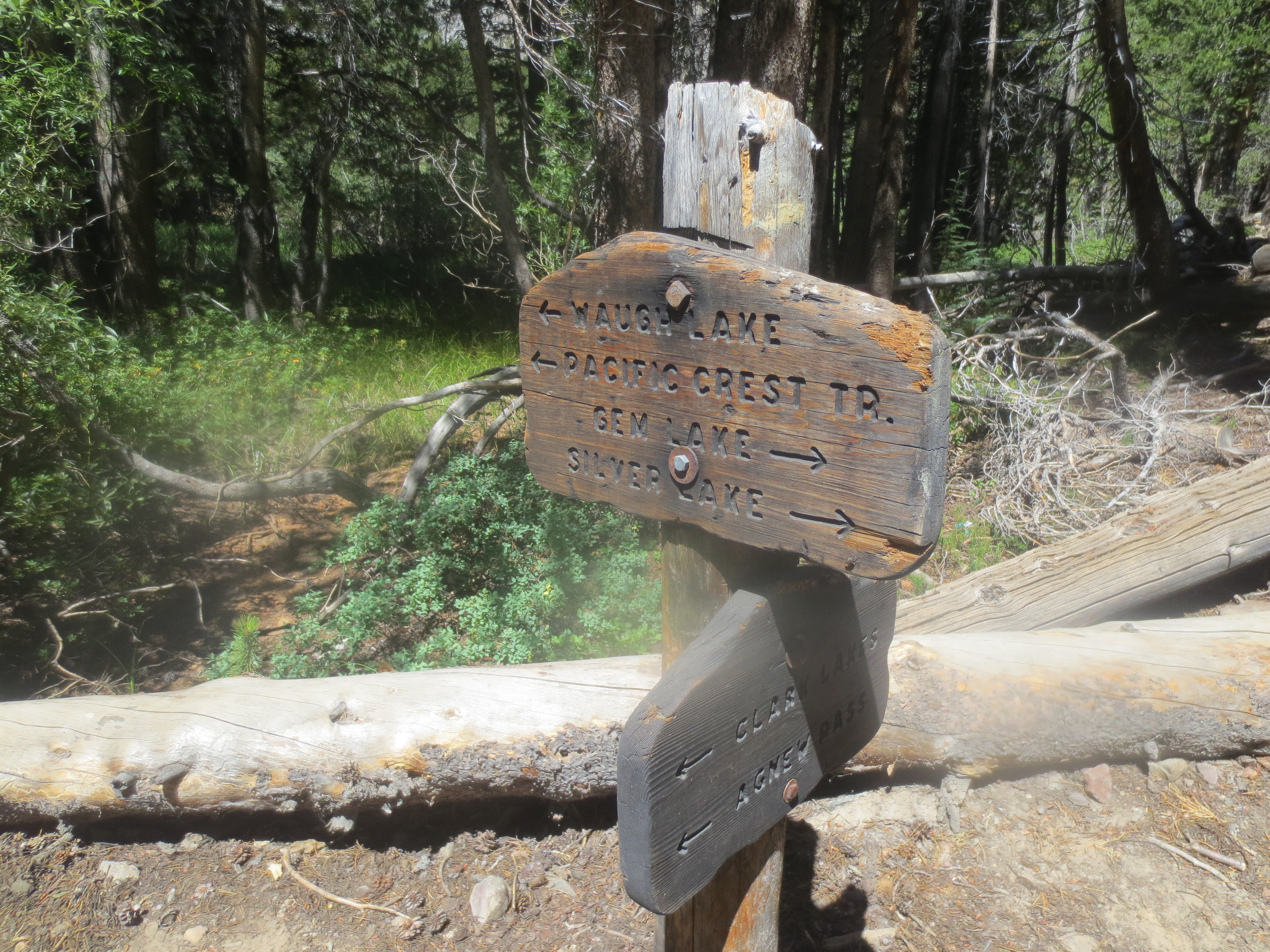 Ahhhh, who doesn’t love forks in the trail. It is like life choices. Which way to go? We decided to head to Waugh Lake. We saw a single older man (our age, haha) hiking this morning and he told us to tell his boys that he was ok. Later, much, later we met the ‘boys’, who were in their late 20’s. Once someones kid, always their kid.
 Along the way we came to Rush Creek and what we called swimmers delight. It was a lovely spot for a mid day swim and picnic.
 Then up and over a small barren pass. Still smiling!
 Man-made Waugh Lake. Is it Wow Lake, or Woe Lake or Wah Lake? Please, we really want to know. We met a big group of teenage boys here with 2 adult ‘leaders’. They are in parenthesis because it appeared that they lacked in leadership ability. It was very unfortunate how most of these young men were equipped. Most looked very uncomfortable. With the backpacking information on the internet and a little time before the hike the leaders should have done a better job.
  An Indian Paintbrush along the way. I thought that the flowers would be about over as it was August, but was pleasantly surprised.
 Island Pass and the junction with the John Muir Trail and we are still hiking along Rush Creek. Rush Creek starts up in Marie Lakes area and goes all the way to Mono Lake.
We decided to camp near the Marie Lake trail head and I think we hiked about 12 miles this day and did a half circle around Ritter and Banner. It was a beautiful hike. We didn’t see very many people until we hit the JMT, and then it was like walking on main-street during the lunch time rush. Group after group heading south to Mount Whitney. We did the JMT hike last year and understand the draw, but still it was a bit much going against the flow, as it was.
We spent the evening fishing Rush Creek. I hooked a few, but didn’t land any. Luckily Mark did. I used to feel bad eating the fish, but last year we met a fisheries scientist and he said the high country creeks need thinning out for the health of the fish. “Eat away”, he said. I say, “Yummy”.
 Leaving our camp early we were up Donahue pass in no time. Gorgeous as always. I spent some of the time thinking on a dream I had last night. I’ve had some inspirational dreams on this hike.
Every night Mark reads aloud in our tent. Last night a quote by Mark Twain caught my fancy and I made sure to write it down, “Always do right. It will gratify some and astonish the rest.” Well, in my dream I was very tempted by greed for money and before I made a decision I woke up. I was a little surprised that I was so tempted in the dream and I thought long and hard about that quote and how it sounds easy, but isn’t. Doing the right thing is best, but it is hard too.
 This was a low snow year in the Sierra, so this was Mark’s first snow cone with a little Vitalyte sprinkled on top. He just loves these things. Always asking people along the way if they’ve seen any snow patches. We met one married couple along this stretch of path and had a good discussion. It is always amazing how along the trail normal social norms pass away and one can have semi deep conversations with complete strangers. Kindred spirits are most of us hikers.
 Now down the other side. There is always something about an open trail that beckons. The freedom, the possibility, the unknown calls to our souls.
 Headwaters of the Lyell Fork of the Tuolumne River.
 In lovely Lyell Canyon we took a lunch break and had a long conversation with Ken who was just finishing the John Muir Trail. He went from Mt. Whitney to here in 10 days! About half the time it took us last year. He was in his 40’s and had traveled to many places we have been, as well as many others. Lovely chat.
  This stretch of creek is very fishable. I had a lot of fun teaching fish to fly. Childlike glee for me, maybe not so much for the fish. My grandma used to say fish don’t have feelings and I hope she was right. There are many ways to dab, but I like to throw my fly in the ripples and let it float down to the fish and then swing them through the air to the bank. Last year we brought a fly rod and reel. This year we opted for small collapsible backpacking casting rods and reels. It works, but it isn’t as beautiful as a fly laid out well on the water. My dad was probably rolling over in his grave watching me fish. Then again probably not.
We had a very cold night camping in Lyell Canyon. 28 degrees when we got up with frost all around us. I had another inspirational dream, but I will spare you. You get the idea. I started thinking I was on a vision quest or something.

Getting off the John Muir Trail we head up the Ireland Lake Trail and met a doe along the way. Graceful dancer of the woods is she.
We had a pretty steep hike up, but with the cold morning air it felt good.
 Wow. All of a sudden we feel like we are in the ‘high’ country. Could be Tibet. Maybe I’m just having another vision.

Behind me is Evelyn Lake. This large windswept meadow has little vegetation and the feel of a high plateau with views straight across to the crest of the Sierra Nevada. Nearby are rocky citadels that remind one of castle ruins.
 Volgelsang High Sierra Camp. We spent a little time here using their bathrooms and washing our faces and hands. Looking in the mirror I realize I have dark circles under my eyes and decide we will make camp ASAP. A day of rest is in order and lovely Booth Lake fits the bill to a T.
 One of our favorite backpacking activities is taking the plunge in icy cold water. It is a pure and almost holy gift. The cold waters invigorating and enveloping all your cells with the ceiling of blue and walls of granite holding it all together. I just can’t seem to get enough of it or be able to find the words to describe the joy.
 While Booth lake is very close to Vogelsang we got there before lunch so we got the prime camping spot on the west side of the lake. There were a couple of other campers by sunset, but the camping sites are all very far apart, so we felt like we had it all to ourselves.
  The fish were biting too. They liked gold spinners. Unfortunately, I didn’t tie one of my spinners on very well and now a fish is sporting a gold lip ring. OOPS. I learned my lesson and make extra loops in my knot now and double-check it too.
 The next morning we hiked down the Rafferty Creek Trail to Tuolumne Meadows. This time of the year Rafferty Creek was dry and the hike was kind of blah. I did enjoy the small birds who were busy with song and industry. It was inspiring how joyously they go about their work. I need to remember this in everyday life.
Tuolumne was a shock. People everywhere. Tourists passing through for the day, campers with RV’s and tents and backpackers of all ages and shapes and levels of cleanliness. We have friends meeting us in 24 hours and I was hoping to find a washer to make myself a little more of a clean hiker. Unfortunately there weren’t any and the bathrooms have signs saying you can’t wash yourself or your clothes.
I opted for a ziploc wash. You put items of clothes in a large ziploc or in my case a large opsak. I added Bronner’s soap and water and sealed the bag and agitated for about 5 minutes. You then drain the water out and add fresh water and rinse. I usually rinse a few times. Hang clothes to dry and they will look pretty presentable. Make sure you are a couple hundred feet from running water. Here is my wash area. Lembert dome in the background. Pretty sweet.
09 Monday Sep 2013
Tags
In August, my husband and I, took a month off from our ranch duties to hike in the Sierra Nevada Mountain Range primarily along the Pacific Coast Trail. This following post is the first section of our journey. It is a very short section.
Our nephew lives in Oakhurst, California and we asked him to give us a ride up Beashore Road to the Mammoth Trail trail head. We stopped at Clover Meadow Ranger Station along the way to pick up a wilderness permit.
Arriving at the trail head at about 4 pm we were eager to take off. The lure of the open trail and tales from my late father were a heady combination.
 My dad loved the mountains and trout fishing and had told us many times to go down to sheep’s crossing. It was an easy 4 mile hike down.
 Along the way Mark found a whole pile of obsidian flakes. There were probably hundreds of them in one little area. The more we dug, the more we found. Alas, we didn’t find any actual points, just the remnants of some Native American’s work. We wondered about his life and what the area looked like then.
  This trails beginning was as a trade crossing for the Native Americans. In the summer months the Paiutes to the east brought obsidian to trade with the natives to the west. I read that on this particular crossing it was mostly Miwok from the west, although the Mono Native Americans might also have been involved. This obsidian we were looking at was very likely part of this trade.

This photo is of the bridge at Sheep’s Crossing. This was August and the river was a bit tame, but the boulder strewn and steep walled canyon was a bit intimidating. We tried our hand at fishing and Mark caught one, while I seemed to have casting issues and my rooster tail kept getting hooked on rocks. Did see plenty of fish as they swam away spooked!
Nice camping spot on the west side of the river. We slept warm with the rain fly off under a blanket of stars with granite cliffs standing as sentinel guards.
 Next morning dawned bright and we left the river behind through crossing the bridge and climbing. It was early and cool, so the climb felt good.
 The meadows surrounding 77 corrals (no corrals anymore) were flower filled.
 Black Eyed Susans, Fireweed and daisies galore.
 At 77 corral there is big camp that looked like a stock camp. The campfire ring had a couple of these log chairs. Comfy.
 We stopped at nearby Cargyle creek for lunch and took a splash in its cheerful waters; basking on the rocks afterwards like lizards in the sun. We fished too by dabbing with flies and caught a couple which we released back into their watery world. We are all for eating, but our midday meal was already done and miles of trail still lay before us.
  The hike soon got more difficult as the trail steepened and it was hot. The wind too had shifted and the smoke for the Aspen Fire started drifting in. It burned your throat and since I have asthma I thought in necessary to wear a mask. It got even hotter and the air escaping the mask sounded a bit like a ventilator. My thoughts turned to my uncle dying with lung cancer. I felt blessed to be alive and trudged on.
 The wind seemed to change a bit, or swirl around at least, and the air cleared a bit while passing beautiful Summit Meadow. We had one more steep push up the granite and volcanic knob to actually get to the summit. I think climbed about 3000 feet from the river.
  Along the way…
Then down, down, down the other side. A few sections flat, others decidedly steep. Huge vistas to the east with Mammoth Mountain center sage then later to the left as the trail turned south. I began to feel fatigue and looked forward to making camp at the creek running somewhere at the bottom.
 We had a lovely campsite all to ourselves and I caught a fish for an appetizer and we took a ridiculous sponge bath while hundreds of mosquitoes feasted on our blood. I think we hiked about 11 miles this day and found ourselves very close to Devil’s Postpile in the morning.
  It was an eery landscape the next morning as the smoke had drifted back in.

We hiked into Red’s Meadow and caught the first morning shuttle for Mammoth. Mark’s insoles were old and causing problems so we picked up a new pair in town and had some pizza and beer. The shuttle services in Mammoth are great. You can get all around town for free and the shuttle from Red’s to Mammoth Village is seven dollars a person round trip. We really love visiting this mountain town.
This trans Sierra hike was 17 miles and can be done easily in 2 days although we took one full day and borrowed a couple hours from 2 others. I’ve read of some über athletes completing the round trip in 1 day. Wow.
The trail’s beginning:
In 1878, J. S. French built a toll trail across the Sierra Nevada from the west; following old established Indian and livestock routes to the new strikes. The “French Trail” began at Fresno Flats (now the town of Oakhurst) 46 miles from Fresno, passed by such historic landmarks as Jackass Meadows, Clover Meadows, and Soldier Meadow and crossed the North Fork of the San Joaquin River. From there, the trail wound up the trail to King Creek and Summit Meadows, down to the Middle Fork of the San Joaquin River, over Mammoth Pass to Pine City and ended at Mammoth City. The trail was known by several names: the “French Trail”, the “Fresno Flats Trail” and the “Mammoth Pass Trail”.
French offered twice-weekly pack train service for riders from Fresno Flats to Mammoth for $15.00 and allowed up to 20 pounds of luggage. The Pine City Feed and Livery Stable also advertised regular pack train trips to Fresno Flats. The Fresno Flats Saddle Trains departed from the Monumental Hotel in Mammoth City on Tuesday and Friday, leaving at 5 AM for the 54-mile journey to Fresno Flats
As with other mining booms, the mines failed, and in 1881, the miners left, the towns declined and eventually disappeared. However, the old “French Trail” continued to be an important thoroughfare across the mountains used by livestock men driving their herds of cattle and sheep into the high mountains for summer grazing.
12 Friday Jul 2013

Our ranch shares a border with Humboldt Redwoods State Park and from time to time we head over the hill and check it out. This time we strapped on our backpacks and went for an overnight. There was something so basic and unaffected about walking right out your door with everything you needed strapped to your back. It made us want to just walk across America or something. Well, maybe not quite. But you get the picture.

Still on our property here. Lovely view of one on our ponds.

Heading out on on main ranch road towards our west ridge. It was hot.

Back into the trees and up the hill. Much cooler here.

Made it to the top of the ridge and the park’s boundary. This board always makes us laugh as it is in the middle of nowhere and we are probably 2 of few who have ever even seen it. Sometimes I want to sneak in and change it to something useful, like a park map, or information on the flora and fauna. But no, it tells how they erased the roads to make the park better. Funny thing is that these signs are all over the park while hoodlums have shot up the useful trail signs that give trail names and how many miles till you get there.

The really big and beautiful redwoods are at the lower elevations along the rivers and creeks, but even up here on the ridge you can find some redwoods.

Lost and then found, faded but full. Trail booty.

A pretty bridge and grassy glen.

Made it the 12.5 miles to our destination, Bull Creek Backpacking camp. Not much here but a wonderful old barn and a pit toilet overgrown by bushes.

We love old dilapidated buildings and thinking about their former lives.

Time to make camp, eat and then drink that old beer we found. It was a little aluminum tasting. YUCK.

Morning along Bull Creek.

And away we go…. Over the hill and through the woods and across a creek or two and by our ponds and to our house we go.
01 Wednesday May 2013

While we were in Las Vegas, we enjoyed hiking a section of the 6 mile long Calico Hills Trail with our grandson, daughter, our dog and our daughter’s dog. 
Lovely light. Gorgeous red rocks.

Blooming Yucca and other flowers too.

Even dead trees look good.

It was an easy and good hike.
